
LEAMAP Version 3.0 Specification
The Lynx Exploration Archivist Map Scanning and Vectorising (LEAMAP) software is a comprehensive software solution for converting hard-copy seismic line location (shotpoint) maps into digital data, and importing and editing existing location data from a variety of formats. Using the utilities provided in the suite, output files can be made ready for loading to seismic interpretation workstation or further processing.
LEAMAP can be used as a standalone system, or can be integrated with LEASSV to provide a full and comprehensive solution for reconstructing seismic data from images of sections and basemaps.
The minimum system requirement is a PC running Microsoft Windows XP, Vista, 7, 8 or 10 (x86 or x64). Over 60 raster file formats are supported via Snowbound Software Inc's raster library. Plotting is supported via standard Windows printer drivers.
Applications contained in the suite are accessed from the Lynx Launcher, a program manager which allows all installed Lynx Exploration Archivist applications to be accessed from the Lynx desktop icon. Installation can be from CD-ROM, or from downloaded setup files.
The LEAMAP suite contains the following applications:
- LOCDIG - seismic basemap digitising
- LOCCONV - import locations from UKOOA/SEG-P1 format
- LOCPREP - edit and re-project location files
LOCDIG
Locdig enables seismic shotpoint location and cultural data to be digitised from a scanned image of a basemap. The main features include:
- Input 60 raster file input formats (TIFF Group-4 recommended)
- Full rotation, zooming and panning of digitised image
- Direct digitising to a Lynx LOC file, shapefile or CSV file
- Advanced calibration using triangulated network
- Point and click editing of points and attributes
- Automatic shotpoint labelling
- Automatic digitising modes
- Snap to symbol, for improving digitised accuracy
- Choose whether to save Lat/Lon, projected XY or pixel coordinates when digitising
- Context sensitive help
- Foreign language menus
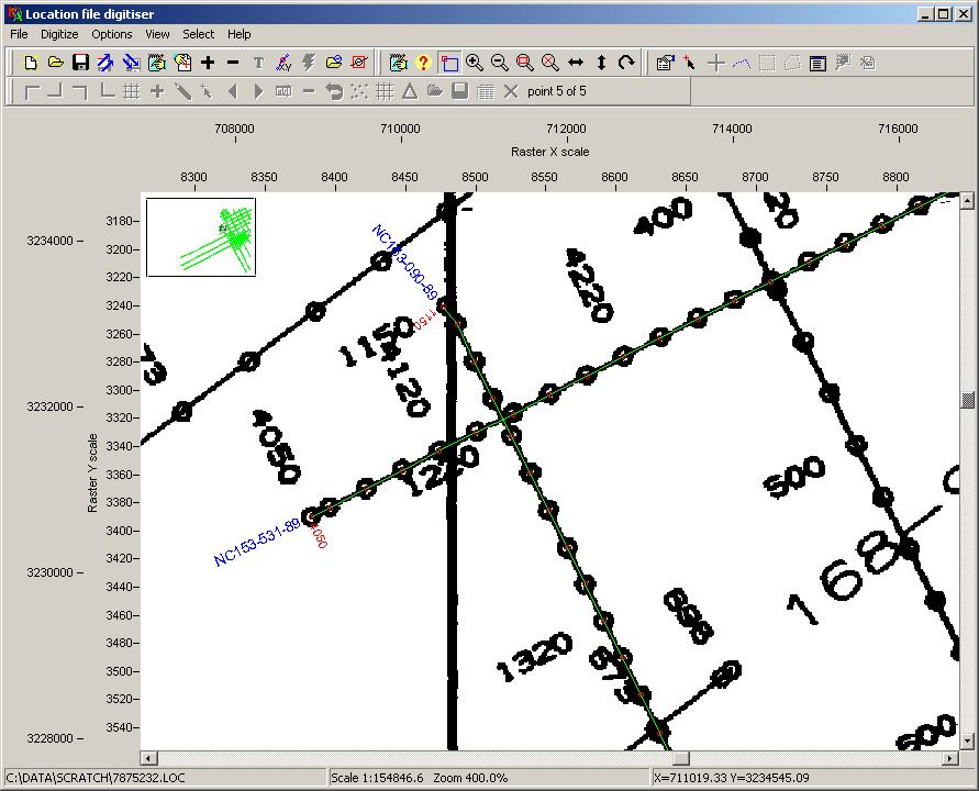
The screenshot above shows digitised seismic locations overlaid on the input scanned basemap.
Locdig implements advanced calibration using a triangulated network, allowing digitising of warped, spliced and badly scanned basemaps. The number of calibration points you need to use usually reflects the quality of the input basemap.
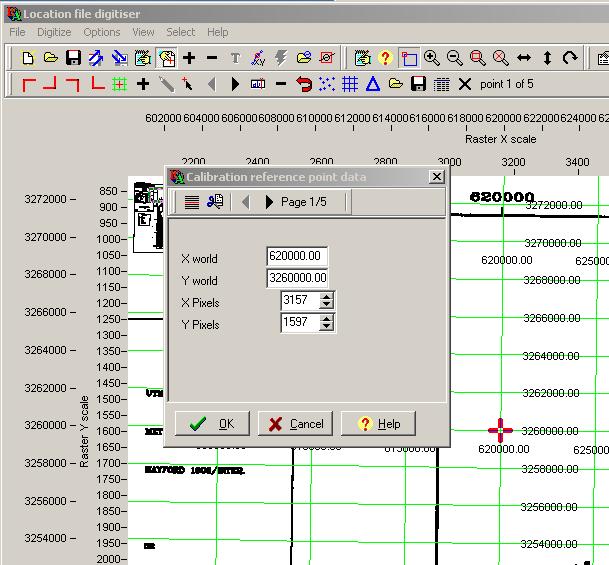
The screenshot above shows the calibration grid (green) overlaying the raster image. The calibration point (red cross) is being edited, to adjust the XY world or pixel coordinates.
LOCCONV
Locconv will import seismic location data from text files and CSV files, and output Lynx LOC files. Seismic location data is usually transferred as some sort of ASCII text file containing a number of coordinate records per seismic line. Each record usually contains the line name, shotpoint number, XY coordinate and/or Lat/Lon coordinate. The format of these files varies enormously. This utility has a flexible field definition to allow you to specify how to convert these files.
Locconv also reads 'standard' UKOOA and SEG-P1 location files in EBCDIC format.
A wizard-style interface leads you through the conversion.
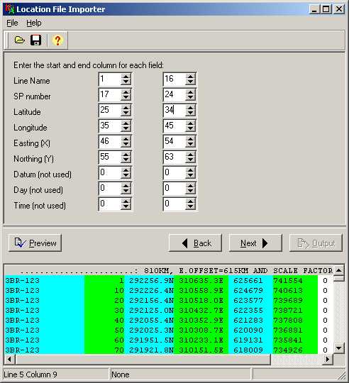
The screenshot above shows data columns from the input file highlighted in the preview window.
LOCPREP
Locprep is an interactive editor for Lynx and UKOOA-type location files, which store seismic shotpoint location information, and can also store general location information. You can use Locprep to perform a variety of tasks with LOC files, including the following:
- Coordinate Shift, Rescale and Projection Conversion
- Rename, Delete and Extract lines
- Edit UKOOA Header
- Decimate shotpoints by Factor, Shotpoint or Distance
- Interactively edit and delete shotpoint values and coordinates
- Interpolate, Extrapolate and Renumber shotpoint ranges
- Join lines and Combine shotpoint ranges
- Split lines
- Merge (concatenate) location files
- Calculate waypoints ("ends and bends")
- Geometry consistency check
- QC map plotting to Windows printers and plotters
- Import from shapefile
- Export to UKOOA/SEG-P1, shapefile, CSV, Landmark cultural formats
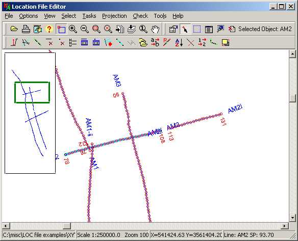
The screenshot above shows a seismic line selected and ready for editing by choosing one of the options on the lower toolbar.
Additional Utilities
Additional utilities are also optionally available for the following tasks:
- Reconstructing seismic line locations from seismic intersection listings
- Inserting XY coordinates into seismic data trace headers (see LEASSV - Traceprep)
Installation files for LEAMAP V3.0
The following setup files comprise the LEAMAP suite, which can be downloaded from here.
- LEASetup - Desktop Launcher, system files and utilities
- LEAMAP - location digitising and editing applications
- BaseviewSetup - Baseview Seismic basemap viewer
To run the software, you will require an activation file or USB dongle from Lynx.
Please contact us for more information on purchasing a licence for LEASSV, or for more information on our seismic vectorising service.