Brazil - Lynx GIS Adviser
This report is one of a series of new GIS products designed to exploit the power and ease of use of ArcGIS as a tool for the Explorationist. The product consists of a wide variety of exploration and production related maps linked to geodatabases and PDF reports. The GIS platform provides users quick and easy access to key hydrocarbon evaluation datasets such as: wells, fields, seismic location maps, blocks & concessions, geology, culture data, satellite imagery and more. An extensive independent study, entitled "Hydrocarbon Potential of the Onshore Basins", containing over 300 pages of text and figures, has also been integrated into the package.
- Basin Geology - Acre, Amazonas, Camamu Almada, Campos, Espirito Santo, Foz do Amazonas, Jequitinhonha, Parana, Parnaiba, Pelotas, Potiguar, Santos, Sergipe Alagoas, Solimoes, Tucano
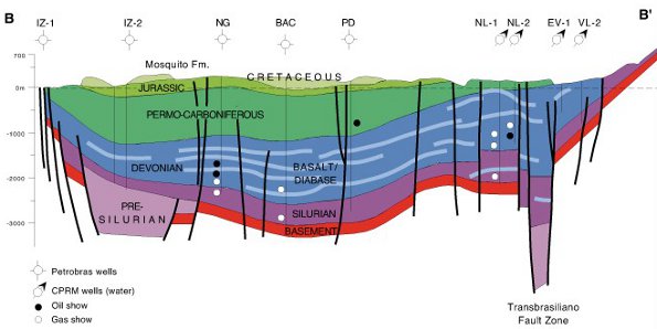
- Basin Cross Sections and Lithostratigraphic Charts
- Regional Geology
- Gravity - Bouger, Freeair, Residual
- Hydrocarbons - Blocks, Concessions (current and relinquished), Fields, Round 8, Seismic Locations (2D and 3D), Wells
- Satellite Imagery - Bathymetry, Landsat (15m and 30m), SRTM (90m)
- Drainage
- Administrative Boundaries
- PDF Report - 329 page fully searchable and indexed in-depth review of the geological makeup and hydrocarbon activity/potential of the onshore basins of Brazil.
Please contact us for a detailed listing.